
Rivers of Time: The Water Bodies of the Guianas
The Guianas—Guyana, Suriname, and French Guiana—form a vast hydrological amphitheater where ancient highlands feed waterways that flow through rainforests to the ocean. The region's rivers and wetlands form an intricate network that has carved landscapes and created biodiverse ecosystems.
From Highlands to Sea: The Spectacular Water Bodies of Guyana, Suriname, and French Guiana
The Guianas—Guyana, Suriname, and French Guiana—exist as a vast hydrological amphitheater where ancient highlands birth countless waterways that cascade through pristine rainforests before merging with the Atlantic Ocean. These waters tell stories spanning geological epochs, from their origins high on the Precambrian Guiana Shield to their final embrace with the sea. The region's rivers, waterfalls, and coastal wetlands form an intricate network that has shaped human civilization, carved landscapes from solid rock, and created some of Earth's most biodiverse aquatic ecosystems.
Unlike many tropical regions where water systems follow predictable patterns, the Guianas present a complex tapestry of waterways flowing through multiple ecological zones. Ancient geological formations channel these waters through spectacular gorges, while coastal plains spread them across vast wetlands and mangrove forests. The result is a hydrological wonderland where thundering waterfalls plunge from tepuis, mighty rivers meander through unexplored forests, and tidal waters create some of the world's most productive estuarine environments.
The Essequibo: Giant of the Guianas
The Essequibo River dominates the region's hydrology, flowing northward for approximately 1,000 kilometers (620 miles) from its origins in the Acarai Mountains near the Brazil-Guyana border to the Atlantic Ocean, its precise headwaters pinpointed only in 2013 by a joint Guyanese-German expedition. As the largest river between the Amazon and Orinoco, the Essequibo drains more than half of Guyana's territory. In recent years, the river has become known internationally not only for its scale but as the namesake of a major territorial dispute between Guyana and Venezuela, covered in full in its dedicated article.
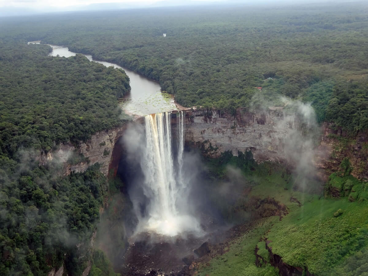
The river's most spectacular feature lies in its middle course, where the Potaro River, one of its major tributaries, creates one of the world's most magnificent waterfalls. Kaieteur Falls plunges 226 meters (741 feet) in a single drop, making it five times taller than Niagara Falls; its full history, the legend of Chief Kai, and its remarkable golden frog (Anomaloglossus beebei), covered in depth in that dedicated article.
The Essequibo's basin encompasses a complex network of tributaries, including the Rupununi, Potaro, Mazaruni, Siparuni, Kiyuwini, Konawaruk, and Cuyuni rivers. Each tributary adds its own character to the system, from the savanna-fed Rupununi, which connects the Essequibo to the Amazon Basin during flood seasons, to the mineral-rich Cuyuni, which carries gold-bearing sediments from the ancient rocks of the Guiana Shield. The river's mouth forms one of South America's most extensive estuarine systems, where freshwater meets the Atlantic in a complex maze of channels, islands, and tidal creeks that support vast populations of scarlet ibis (Eudocimus ruber), roseate spoonbills (Platalea ajaja), and countless other waterbirds.
Border Rivers: Natural Boundaries of Nations
The political boundaries of the Guianas follow the natural courses of several major rivers, creating international borders that have shaped regional history, culture, and ecology. These transboundary waterways serve simultaneously as barriers and bridges, dividing nations while connecting ecosystems and communities across artificial political lines, and nowhere is this more consequential today than along the Essequibo itself, whose entire western bank is claimed by Venezuela as its own territory in a dispute that reached the International Court of Justice's merits phase in 2026.
The Corentyne River forms the eastern boundary between Guyana and Suriname, rising in the Acarai Mountains and flowing northward for approximately 724 kilometers (450 miles), draining vast areas of pristine rainforest before reaching the sea. The river's upper reaches remain largely unexplored, and its waters support important fisheries, including populations of the giant catfish Brachyplatystoma filamentosum, which can reach lengths exceeding 3 meters (10 feet) and migrate between the river's upper reaches and the Atlantic Ocean, following ancient patterns that connect Amazonian and Guianan ecosystems.
The Maroni River forms the boundary between French Guiana and Suriname, rising in the Tumuc-Humac Mountains near the Brazilian border and flowing northward through dense tropical rainforests to enter the Atlantic. The total river system, including its upper reaches known as the Litani and Lawa, totals 612 kilometers (380 miles). The Maroni represents one of South America's wildest rivers, its upper reaches accessible only by dugout canoe or small aircraft; local communities, including Amerindians and the Bushinenge (Maroon descendants of escaped enslaved Africans), have long occupied both banks without distinction, creating a cultural landscape that transcends modern political boundaries. The Maroni's tributaries, including the Tapanahoni, Paloemeu, and Oelemari rivers, drain distinct ecological regions of the Guiana highlands and serve as highways for wildlife movement and human transportation alike.
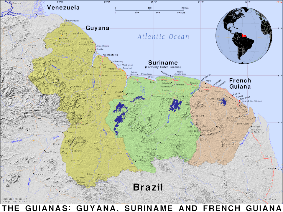
Map of the Guianas.
Suriname's River Networks
At the heart of Suriname lies the Suriname River, a 480-kilometer (300-mile) waterway that serves as the country's most important transportation corridor. Beginning in the Guiana Highlands as the Gran Rio, the river flows through the center of the country, passes through the capital city of Paramaribo, and reaches the Atlantic Ocean; its depth and width allow large container ships to navigate upstream to ports at Paramaribo, Paranam, and Smalkalden, making it the nation's economic lifeline.
The Suriname River's watershed encompasses a remarkable diversity of ecosystems, from montane forests in its headwaters to coastal mangroves at its mouth. Along its middle course, the river passes through the Central Suriname Nature Reserve, one of the largest protected areas in the tropics, where pristine forests harbor populations of jaguars (Panthera onca), giant river otters (Pteronura brasiliensis), and hundreds of bird species.
The Saramacca River parallels the Suriname River to the west, draining a similarly diverse landscape while remaining more remote in character. Its upper reaches provide critical habitat for the vulnerable Amazon river dolphin (Inia geoffrensis), whose range extends into the Guiana rivers despite its primary association with the Amazon Basin, making the Saramacca's undisturbed forests a refuge for species that have disappeared from more developed watersheds. The Coppename River, flowing through central Suriname, shows the Guiana Shield's complex hydrology, its course interrupted by numerous rapids and waterfalls where resistant rock formations create natural barriers to navigation; these rapids serve as natural fish ladders, allowing migratory species to move between elevations while creating distinct aquatic habitats at each level.
French Guiana's Waterways
French Guiana's river systems, while smaller than those of its neighbors, play equally important roles in the region's ecology and human geography. The Oyapock River marks the eastern boundary with Brazil, flowing northward from the Tumuc-Humac Mountains through 403 kilometers (250 miles) of pristine rainforest before reaching the Atlantic Ocean. Its waters support the northernmost populations of many Amazonian fish species, creating a biogeographical link between the Guiana Shield and the Amazon Basin; its tidal reaches also support important populations of the West Indian manatee (Trichechus manatus), which migrate between coastal waters and the river's lower reaches to find freshwater vegetation.
The Sinnamary River, flowing through the heart of French Guiana, has been significantly altered by the construction of the Petit-Saut Dam, creating one of South America's largest artificial lakes, a reservoir covering 310 square kilometers (120 square miles) that demonstrates both the potential and the challenges of hydroelectric development in tropical river systems. The Approuague River, by contrast, maintains a more natural character, flowing unimpeded from the interior highlands to the Atlantic coast; its watershed encompasses some of French Guiana's most pristine forests, serving as a refuge for species such as the giant otter and the black caiman (Melanosuchus niger) that have become rare in more developed watersheds.
Coastal Waters and Estuarine Systems
Where the Guianas' rivers meet the Atlantic Ocean, some of the world's most productive and dynamic coastal ecosystems emerge. The coastline extends for approximately 1,800 kilometers (1,118 miles), much of it fringed by extensive mangrove forests that rank among the most pristine in the Western Hemisphere. These mangroves, dominated by red mangroves (Rhizophora mangle), black mangroves (Avicennia germinans), and white mangroves (Laguncularia racemosa), create intricate networks of tidal creeks and channels that serve as nurseries for countless marine species.
The mudflats created by river sediments provide critical habitat for millions of migratory shorebirds, including the red knot (Calidris canutus) and semipalmated sandpiper (Calidris pusilla), which depend on these coastlines during their epic migrations between Arctic breeding grounds and southern wintering areas, their arrival timed to coincide with the emergence of horseshoe crab eggs in one of nature's most spectacular feeding events.
Rapids, Waterfalls, and Geological Wonders
The ancient geology of the Guiana Shield creates countless obstacles to river flow, resulting in spectacular rapids and waterfalls that punctuate nearly every major waterway in the region. Beyond Kaieteur, the region harbors hundreds of lesser-known but equally impressive cataracts. Orinduik Falls, on the Ireng River, creates a series of cascades where flowing water has naturally polished jasper and other semi-precious stones, creating a geological wonderland of colorful rocks and crystal-clear pools. King Edward VII Falls, on the Courantyne River system, shows water's power to carve through solid rock, compressing the river into a channel barely 20 meters (66 feet) wide and generating a natural spectacle of whitewater and mist audible for kilometers through the surrounding forest.
The Rewa River, a tributary of the Essequibo, showcases the typical pattern of Guianan waterways, with alternating sections of calm water and dramatic rapids, known locally as "falls," that create distinct aquatic habitats supporting different assemblages of fish species, some specifically adapted to the turbulent, high-velocity conditions found there.
Unique Ecosystems and Biodiversity
The Guianas' water bodies support extraordinary biodiversity, with many rivers harboring endemic species found nowhere else on Earth; the Essequibo's freshwater habitat alone is home to nearly 60 endemic fish species. The region's rivers serve as corridors for wildlife movement, allowing species to migrate between ecological zones and maintain genetic connectivity across vast distances. During the dry season, rivers become concentrated sources of water that draw terrestrial animals from throughout their watersheds, creating spectacular concentrations of wildlife along riverbanks.
Many Guianan rivers also exhibit the phenomenon of "blackwater," where dissolved organic compounds from forest soils create tea-colored water with extremely low pH. These acidic conditions support unique biological communities adapted to the challenging chemistry, including specialized fish species and aquatic plants that cannot survive in more neutral waters.
Cultural Significance and Human Heritage
The rivers of the Guianas have served as highways for human civilization for thousands of years. Indigenous communities, whose broader history and culture are covered in our Guianas overview, developed sophisticated knowledge of river navigation, seasonal patterns, and aquatic resources, reflected in the dozens of specific terms many Indigenous languages hold for different types of water bodies. Amerindian peoples developed remarkable watercraft technologies, carving dugout canoes from single tree trunks capable of navigating both calm waters and treacherous rapids, using techniques that have remained largely unchanged for centuries.
Colonial history in the Guianas is closely tied to the region's river systems, as European settlers used waterways for exploration, trade, and territorial expansion; many of the region's oldest settlements were established at strategic points along major rivers, where natural harbors or tributary confluences offered advantages for commerce and defense. The legacy of the plantation era remains visible along many Guianan rivers today, where abandoned sugar and coffee estates, now largely reclaimed by forest, testify to the complex colonial history that shaped the region's modern political and cultural geography.
Modern Challenges and Conservation
Contemporary threats to the Guianas' water bodies center on mining activity, particularly the small-scale gold mining described in depth in our Guiana Shield article, whose mercury amalgamation techniques release a toxic metal into watersheds across the region, posing health risks to wildlife and human communities alike. Deforestation, while less severe here than in many other tropical regions, still threatens watershed integrity by altering rainfall patterns, increasing erosion, and changing the chemical composition of river water. Climate change adds a further layer of risk, as altered precipitation patterns may disrupt the seasonal rhythms many species depend on for reproduction and migration, while rising sea levels threaten to push saltwater intrusion further upstream.
Even so, the remoteness and low population density of much of the Guianas provide real protection: large areas of pristine watershed remain intact, supporting complete assemblages of native species and maintaining natural ecological processes, and international cooperation between the three countries has led to transboundary protected areas that safeguard critical river systems. Indigenous communities play a crucial role in these efforts as well, since their traditional territories often encompass large watersheds that remain in pristine condition, and integrating traditional ecological knowledge with modern conservation science offers one of the most promising paths toward protecting these irreplaceable aquatic ecosystems while respecting Indigenous rights.
Conclusion
From the thundering cascade of Kaieteur Falls to the quiet meanders of forest streams, from the contested waters of the Essequibo to the crystal rapids of highland tributaries, the waters of the Guianas flow through landscapes that remain largely as they were millions of years ago, carrying the genetic heritage of countless endemic species and the cultural memory of the Indigenous peoples who have lived alongside them since time immemorial. As freshwater resources grow scarcer worldwide, these largely intact watersheds offer a rare demonstration that a major tropical river system can still flow through unbroken forest, even as mining pressure, deforestation, and an unresolved international dispute over the region's largest river test how long that can remain true.