
The Amazon River System: Nature's Mightiest Waterway
The Amazon River channels the flow of over 1,100 tributaries across 6.3 million sq km into a single waterway, delivering 209,000 cubic meters of water per second to the Atlantic — 15-20% of all freshwater entering the world's oceans, and the physical thread that connects the Andes to the Atlantic across an entire continent.

The Amazon River: A Continent's Circulatory System
The Amazon River stands as Earth's most powerful single waterway, channeling the flow of over 1,100 tributaries across 6.3 million sq km (2.4 million sq mi) into a current that delivers 209,000 cubic meters (7.4 million cubic ft) of water per second to the Atlantic Ocean. This colossal flow represents 15-20% of all freshwater entering the world's oceans, making the Amazon not just South America's arterial system but a critical component of global ocean circulation and climate regulation.
Serving as the liquid lifeline of Amazônia, the river functions as both a highway for life and an engine of global weather, transporting nutrients across a continent while generating atmospheric moisture that influences precipitation from Argentina to North America. From its headwaters high in the Peruvian Andes to its vast Atlantic mouth, this liquid giant demonstrates water's power to shape landscapes, sustain ecosystems, and connect environments across thousands of kilometers.
From the Andes to the Atlantic
The Amazon's headwaters rise at over 5,000 m (16,400 ft) elevation in the Peruvian Andes, where glacial melt and mountain precipitation feed the streams that will eventually become the world's most voluminous river. Exactly which of these headwater streams counts as the Amazon's true source remains genuinely disputed: for decades the Apurímac River, rising near Nevado Mismi, was treated as the accepted source, giving the river a total length of roughly 6,400 km (4,000 mi), but more recent expeditions have proposed the Mantaro River, further north in the Cordillera Rumi Cruz, as an alternative and marginally longer source. As the chosen headwater stream descends through Peru's eastern Andes, it gains volume from countless mountain tributaries, transforming from a turbulent mountain river into the broader Ucayali River by the time it reaches the Amazon lowlands.
The Amazon proper begins at the confluence of the Ucayali and Marañón rivers near Iquitos, Peru. From here the river flows eastward across remarkably flat terrain, dropping an average of just 2 cm per km (1.3 in per mi), so gently that its width varies dramatically along the way, from 1.6 km (1 mi) at Iquitos to over 10 km (6.2 mi) during flood season near its mouth, and as much as 48 km (30 mi) across at its widest flooded points. Despite its immense volume, the river flows relatively slowly, averaging just 2-5 km per hour (1.2-3.1 mph), a sluggishness that allows sediment to settle and produces the meandering channel pattern typical of lowland rivers everywhere. At its mouth, the Amazon discharges a freshwater plume extending some 400 km (250 mi) into the Atlantic, with fresh water detectable as far as 160 km (100 mi) offshore and its sediment plume visible from space.
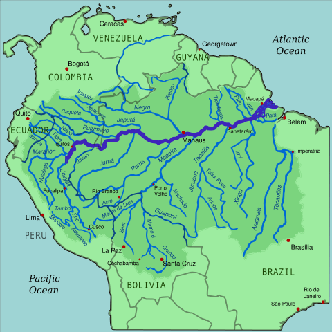
Map depicting the Amazon River drainage basin with the Amazon River and its tributaries highlighted.
A Network of Rivers as Mighty as the Amazon Itself
The Amazon's tributary system includes 17 rivers exceeding 1,500 km (930 mi) in length, each substantial enough to rank among the world's major rivers in its own right. The Madeira River, at 3,250 km (2,020 mi), is the Amazon's longest tributary, draining Bolivia's highlands and carrying the second-largest sediment load of any river on Earth. The Purús River (3,210 km/1,995 mi) meanders extensively through Peru and Brazil with extreme seasonal variation in flow, while the Japurá River (2,820 km/1,750 mi), originating in Colombia as the Caquetá, illustrates just how international this river system really is. The Negro River (2,250 km/1,400 mi), the largest blackwater tributary anywhere in the world, meets the Amazon's sediment-laden waters at Manaus in the famous "Meeting of the Waters," where the two rivers' contrasting colors run side by side for several kilometers before finally mixing. These and other tributaries fall broadly into the whitewater, blackwater, and clearwater categories, covered in ecological depth in our Amazon Biome article; this chemical classification, rooted in each river's source geology, shapes everything from floodplain fertility to the fish communities each type of water can support.
Flood, Sediment, and the Hidden Water Below
The Amazon's annual flood pulse, and the broader hydrological rhythms it drives across the basin, are covered in detail in our Amazon Basin article. Within the main river channel itself, the effect is dramatic: water levels at Manaus can vary by nearly 20 m (66 ft) between high and low water, and the river transports an estimated 1.3 billion tons of sediment annually, over 90% of it originating from the Andean region that makes up just 12% of the total basin. Most of that sediment settles onto várzea floodplains during the annual floods, building some of the most fertile agricultural soils on the continent, while the fraction that reaches the Atlantic influences coastal geomorphology as far away as the Guianas.
Less certain, but genuinely intriguing, is the Amazon's relationship with the water beneath it. A 2011 study identified a deep, slow-moving flow of groundwater through porous rock roughly 4,000 m (13,100 ft) beneath the river, popularly nicknamed the "Hamza River" after the lead researcher; while media coverage has sometimes described this as a second Amazon flowing underground at comparable volume, the finding is better understood as an extremely slow-moving body of groundwater rather than a river in any conventional sense, and the scale of its flow remains a subject of ongoing scientific debate. Less disputed is that groundwater reserves beneath the Amazon Basin may be vast, with some estimates exceeding 100 times the river's annual surface flow, representing a water resource of real significance for future climate scenarios regardless of how the deep flow is ultimately characterized.
A Freshwater Ocean of Fish
The Amazon supports the richest freshwater fish fauna on Earth, with over 3,000 described species and estimates suggesting the true total may exceed 5,000. Species range from tetras weighing less than a gram to giant catfish (Brachyplatystoma spp.) exceeding 100 kg (220 lb) and 2 m (6.6 ft) in length, and fish here fill nearly every conceivable ecological niche: fruit-eaters like the tambaqui (Colossoma macropomum), wood-borers (Panaque spp.), scale-eaters (Catoprion spp.), and even small parasitic catfish (Vandellia spp.) that feed on the blood of other fish. Many large species migrate thousands of kilometers to spawn, while others practice sophisticated parental care, including mouthbrooding and nest-guarding.
The river's larger vertebrates are equally distinctive. The Amazon river dolphin (Inia geoffrensis), the largest river dolphin species on Earth, reaches lengths of 2.5 m (8.2 ft) and relies on echolocation to navigate the river's murky water, while the black caiman (Melanosuchus niger), the Amazon's largest predator at up to 6 m (20 ft), functions as a keystone species throughout the aquatic food web. The giant river otter (Pteronura brasiliensis) hunts cooperatively in social family groups, and the West Indian manatee (Trichechus manatus) grazes on aquatic vegetation in the river's quieter backwaters and mouths.
Highways of Water: Human Life on the River
Indigenous peoples have navigated and read the Amazon's waters for millennia, developing detailed ecological calendars that track fish runs, fruiting seasons, and flood timing, and building architecture, agriculture, and settlement patterns adapted to the annual rhythm of high and low water; in some communities, they maintain separate wet-season and dry-season dwellings entirely. That relationship with the river as highway continues today at industrial scale: ocean-going vessels of up to 40,000 tons can reach Manaus year-round despite the city sitting 1,500 km (930 mi) inland, while smaller vessels and passenger boats known as recreios serve as buses, delivery trucks, and social hubs for the many riverside communities that have no road access at all.
Three cities anchor this river-based world. Manaus, at the Negro-Amazon confluence, is a metropolitan area of roughly 2.2 million people and the region's economic hub, its ocean-shipping access a direct product of the Amazon's extraordinary depth this far inland. Iquitos, Peru, home to roughly 400,000 people, holds the distinction of being the world's largest city with no road access, reachable only by river or air. And Belém, at the river's Atlantic mouth, serves as the Amazon's principal port, handling more than 13 million tons of cargo each year as the gateway between the river system and the ocean beyond.
Fisheries, Dams, and the River's Economic Weight
Subsistence fishing sustains millions of riverside residents, with per capita fish consumption exceeding 50 kg (110 lb) annually in many communities, while commercial species including pirarucu (Arapaima gigas) and tambaqui support regional economies well beyond the river's immediate banks. Hydroelectric development has become the river system's most consequential and contested economic use: over 150 dams already operate on Amazon tributaries, generating roughly 40,000 megawatts, and further proposed projects could add 70,000 megawatts more, development that offers genuinely clean energy but risks fragmenting river systems, blocking fish migration routes, and severing the floodplain connectivity that much of the basin's ecology depends on, tensions covered in the specific case of the Xingu River's Belo Monte Dam in our Amazônia overview.
A River Under Pressure
The Amazon faces mounting environmental pressure on several fronts. Mercury from gold mining, an estimated 2,000 tons introduced into Amazonian waterways over the years, threatens both fish and human health throughout the basin, while growing cities discharge untreated sewage and expanding soy cultivation and cattle ranching add fertilizer and pesticide runoff to river systems already under strain. Deforestation compounds all of this: forest loss alters precipitation patterns, increases surface runoff and erosion, and severs the terrestrial-aquatic connections many species depend on, while climate change threatens to intensify both extreme flood and extreme drought years alike, with recent severe droughts in 2005, 2010, and 2015 exposing vast stretches of riverbed and stranding communities that depend entirely on boat access.
Conservation responses increasingly focus on watershed-scale rather than segment-by-segment protection, coordinated in part through the same transboundary cooperation covered in our Amazônia article, alongside community-based fisheries management that has, in several documented cases, successfully rebuilt depleted fish populations through local quotas, seasonal closures, and gear restrictions.
Conclusion
The Amazon River is South America's circulatory system in the most literal sense, connecting Andean headwaters with Atlantic lowlands and sustaining the most diverse freshwater ecosystem on the planet along the way. Its health affects not only the tens of millions of people living within its watershed, but also global climate stability and ocean chemistry patterns that shape weather far beyond South America's shores. From glacial streams whose exact source scientists still debate to a river mouth wide enough to be seen from space, every part of this system contributes to its function as Earth's mightiest waterway, and its future now depends on how well the nations and communities who depend on it can manage what remains, by any measure, one of the planet's most essential life-support systems.