The Geography of Guatemala: Where Ancient Civilizations Meet Modern Conservation Challenges
Guatemala holds a strategically vital position in Central America, serving as a bridge between North and South America. This key location has profoundly shaped its history, culture, and economic development, while its diverse topography has made it one of the most biodiverse regions in the world.

 https://www.flickr.com/photos/67769030@N07/15772729409")


 https://www.flickr.com/photos/archer10/2214589482")
From Maya Highlands to Caribbean Coasts: Understanding Guatemala's Geographic Diversity
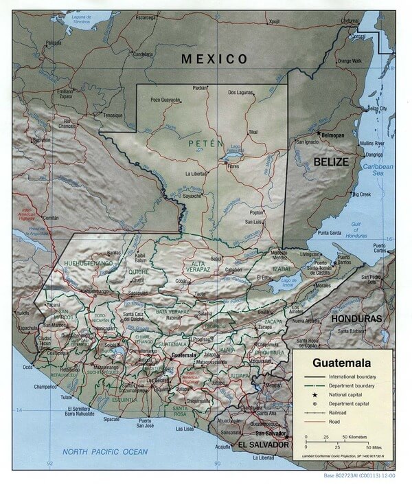
Guatemala, officially the Republic of Guatemala, occupies a strategically important position in Central America, serving as a geographic and cultural bridge between North and South America. Located between approximately 13°45'N to 17°49'N latitude and 88°14'W to 92°14'W longitude, this mountainous nation covers an area of 108,889 square kilometers (42,042 square miles), making it slightly smaller than the U.S. state of Pennsylvania. The country is bordered by Mexico to the north and west, Belize to the northeast, Honduras to the east, El Salvador to the southeast, the Pacific Ocean to the southwest, and the Caribbean Sea to the northeast. This strategic location has profoundly influenced Guatemala's history, culture, and economic development, while its dramatic topographic diversity has created one of the most biodiverse nations in Central America.
Physical Geography and Topography
Major Geographic Regions
Guatemala's surface is characterized by three major topographical features that can also be defined as geographic regions: the Petén Lowlands, the Guatemalan Highlands, and the Pacific Coast Flatlands, with a fourth minor zone being the Caribbean Coast. These distinct regions create a remarkable diversity of landscapes, climates, and ecosystems within a relatively compact area.
Two mountain chains enter Guatemala from west to east, dividing Guatemala into three major regions: the highlands, which dominate the central and western portions of the country and represent the most densely populated and culturally significant areas of the nation.
The Guatemalan Highlands
The Guatemalan Highlands constitute the most geographically and culturally significant region of the country, extending across the central and western portions of Guatemala. These high mountain ranges and valleys arc gently eastward from Mexico for a distance of 210 miles (340 km), extending into northern Honduras. This mountainous backbone of Guatemala is dominated by the Sierra Madre range, which forms part of the larger Central American volcanic arc.
The towering Sierra Madre range spans across much of Guatemala, shaping its topography and influencing climate patterns. Within this system lies one of the most spectacular volcanic landscapes in the Americas. The mountain chain is characterized by steep volcanic cones, including Tajumulco Volcano at 4,220 meters (13,845 feet), the highest point in the country and Central America. All of Guatemala's 37 volcanoes, three of which are active (Pacaya, Santiaguito, and Fuego), are located in this mountain chain.
The highlands are further subdivided into several distinct mountain ranges, each with unique characteristics and ecological significance. The Sierra de las Minas mountain range and Biosphere Reserve are among Guatemala's most ecologically and geographically significant areas. This range, spanning southeastern Guatemala, is renowned for its rugged terrain, diverse ecosystems, and remarkable biodiversity.
The volcanic nature of the highlands has created exceptionally fertile soils derived from volcanic ash and lava weathering. These fertile volcanic soils, combined with the moderate temperatures found at higher elevations, have made the highlands the agricultural heartland of Guatemala and home to the majority of the population.
The Petén Lowlands
The Petén region occupies the northern third of Guatemala and represents the country's largest geographic region. Dense tropical rainforests, wetlands, and scattered savannas characterize this vast lowland area. The terrain is generally flat to gently rolling, with elevations rarely exceeding 200 meters (656 feet) above sea level.
The Petén lowlands are geologically distinct from the volcanic highlands, consisting primarily of limestone bedrock that has been shaped by millions of years of tropical weathering and erosion. This karst landscape features numerous caves, underground rivers, and cenotes (natural sinkholes), which were considered sacred by the ancient Maya and continue to play a crucial role in local hydrology.
This region contains some of Guatemala's most pristine natural areas, including the Maya Biosphere Reserve, which encompasses over 2.1 million hectares (5.2 million acres) and represents one of the largest protected areas in Central America. The Petén serves as Guatemala's primary frontier with Mexico and contains significant archaeological sites, including the famous Maya city of Tikal.
Pacific Coast Flatlands
Guatemala's Pacific coast extends for approximately 250 kilometers (155 miles) along the Pacific Ocean and is characterized by a narrow coastal plain that rarely exceeds 50 kilometers (31 miles) in width. This region consists of fertile alluvial plains formed by sediments carried down from the volcanic highlands by numerous rivers.
The coastal plain is divided into two distinct zones: the immediate coastal area, characterized by its black volcanic sand beaches and mangrove swamps, and the slightly elevated interior plain, which is extensively used for agriculture, particularly for sugar cane, cotton, and cattle ranching. The proximity to active volcanoes means that this region benefits from some of the world's most fertile soils, though it also faces risks from volcanic activity and seismic events.
Caribbean Coast
Guatemala's Caribbean coastline is much shorter than its Pacific coast, extending only about 75 kilometers (47 miles) along the Caribbean Sea. This region is characterized by a narrow coastal plain backed by the foothills of the Sierra de las Minas. The coast features a mix of sandy beaches, river deltas, and mangrove forests.
The Caribbean coastal region is culturally and economically distinct from the rest of Guatemala, with significant Afro-Caribbean populations and economic ties to the broader Caribbean basin. The region's major port, Puerto Barrios, serves as Guatemala's primary gateway to Atlantic shipping routes.
Guatemala relief map.
Hydrographic Systems
Major River Systems
Guatemala's river systems are organized around several major watersheds that drain toward both the Pacific Ocean and the Caribbean Sea. The Continental Divide runs roughly through the center of the country, separating the Atlantic and Pacific drainage basins.
The Motagua River, one of Guatemala's major rivers, flows through the eastern part of the country, providing a crucial source of water resources. The Motagua is Guatemala's longest river, stretching approximately 486 kilometers (302 miles) from its source in the western highlands to its mouth on the Caribbean coast. This river system drains much of the central highlands and serves as an important transportation corridor and source of hydroelectric power.
Other significant rivers include the Usumacinta, which forms part of the border with Mexico and drains the northern Petén region toward the Gulf of Mexico. On the Pacific side, numerous shorter but swift-flowing rivers descend from the volcanic highlands, including the Suchiate, which forms the border with Mexico.
Lake Atitlán and Other Water Bodies
Lake Atitlán, located in the western highlands at an elevation of 1,562 meters (5,125 feet), is one of Guatemala's most famous geographic features. This large crater lake, formed by volcanic activity approximately 84,000 years ago, covers an area of 130 square kilometers (50 square miles) and reaches depths of over 300 meters (984 feet). The lake is surrounded by three massive volcanoes—Atitlán, Tolimán, and San Pedro—creating one of the most spectacular landscapes in Central America.
Lake Atitlán is the only place in the world where the rare flightless waterbird known as the Atitlán grebe (Podilymbus gigas) once lived. However, this endemic species became extinct in the 1980s due to environmental pressures and the introduction of non-native species.
Other significant water bodies include Lake Izabal, Guatemala's largest lake, which covers approximately 589 square kilometers (227 square miles) in the eastern part of the country. This freshwater lake drains toward the Caribbean through the Dulce River, supporting important fisheries and transportation networks.
Climate and Weather Patterns
Altitudinal Climate Zones
Located within the tropics and with elevations ranging from sea level to more than 13,000 feet (4,000 meters), Guatemala experiences a diverse range of climates. Below 3,000 feet (900 metres) in elevation, average monthly temperatures range between 70 and 80 °F (21 and 27 °C) throughout the year; between 3,000 and 5,000 feet (900 and 1,500 metres), temperatures range between 60 and 70 °F (16 and 21 °C); and from 6,000 to 9,000 feet (1,500 to 2,700 metres), they range between 50 and 60 °F (10 and 16 °C).
This altitudinal zonation creates distinct climate regions that have profoundly influenced human settlement patterns, agricultural practices, and the distribution of biodiversity. The tropical lowlands of Petén and the Caribbean coast experience consistently warm temperatures and high humidity throughout the year, while the volcanic highlands enjoy more temperate conditions, which have attracted the majority of Guatemala's population.
The highest elevations, particularly around the major volcanic peaks, can experience temperatures near freezing, and frost is not uncommon during the dry season. These cooler highland areas support different vegetation types and crops, including temperate zone species that cannot survive in the hot lowlands.
Seasonal Patterns
Guatemala's climate is characterized by distinct wet and dry seasons rather than significant temperature variations throughout the year. The dry season, locally known as "verano" (summer), typically extends from November to April, while the wet season or "invierno" (winter) runs from May to October.
During the wet season, the country receives the majority of its annual precipitation, with rainfall patterns heavily influenced by topography. The Pacific coast and southern highlands receive most of their precipitation from moisture-laden air masses moving inland from the Pacific Ocean. These air masses are forced to rise as they encounter the volcanic mountains, creating orographic precipitation that can exceed 4,000 millimeters (157 inches) annually on windward slopes.
The Petén lowlands experience a somewhat different rainfall pattern, with precipitation influenced by both Pacific and Caribbean weather systems. This region typically receives between 1,200 and 2,000 millimeters (47 to 79 inches) of annual rainfall, with a pronounced dry season that can last up to five months.
Biogeography and Ecosystems
Biodiversity Overview
According to ParksWatch and the IUCN, Guatemala is considered one of the world's five biodiversity hotspots. The country has 14 ecoregions, ranging from mangrove forests (4 species) in both ocean littorals to dry forests and scrublands in the eastern highlands, subtropical and tropical rainforests, wetlands, cloud forests in the Verapaz region, mixed forests, and pine forests in the highlands.
Guatemala's floral diversity currently has 321 families, 2,478 genera, and 10,317 species (including algae, lichen, mushrooms, and hepatic plants). Eight hundred twenty-three species represent some type of endemism, and 538 are restricted to Guatemala. Regarding fauna, there are 192 species of native mammals, 486 bird species, and numerous other vertebrate and invertebrate groups.
Guatemala is home to at least 8,682 species of vascular plants, of which 13.5% are endemic to the country. This remarkable diversity reflects the country's position at the junction of North and South American biogeographic regions, its diverse topography, and its range of climate zones.
Forest Ecosystems
Over one-third of Guatemala (36.3%, or approximately 39,380 km²) is forested (as of 2005). Approximately half of the forests (49.7%, or roughly 19,570 km²) are classified as primary forests, considered the most biodiverse forest types.
The tropical rainforests of the Petén represent Guatemala's most extensive forest ecosystem and are part of the larger Mesoamerican Biological Corridor. These forests support an incredible diversity of tree species, including economically important hardwoods such as mahogany (Swietenia macrophylla), cecropia (Cecropia spp.), and various fig species (Ficus spp.). The Maya Biosphere Reserve is home to an impressive array of flora, including breadnut, mahogany, cedar, and allspice.
The highland forests include cloud forests, pine forests, and mixed pine-oak forests. Cloud forests, found at elevations between 1,200 and 3,000 meters (3,937 to 9,843 feet), are characterized by persistent cloud cover and support numerous endemic species, including many orchids and bromeliads. Pine forests, dominated by species such as Pinus oocarpa and Pinus maximinoi, occur at higher elevations and are adapted to the cooler temperatures and seasonal droughts of the highlands.
Fauna Diversity
The country is a sanctuary for over 8,061 known species of amphibians, birds, mammals, fish, reptiles, and invertebrates. The wildlife of Guatemala features iconic animals, such as jaguars and the Resplendent Quetzal, a bird of great cultural significance.
These dense forests are home to a wide variety of wildlife, including jaguars, ocelots, tapirs, and howler monkeys. Bird species such as the keel-billed toucan, scarlet macaw, and the resplendent quetzal, Guatemala's national bird, thrive in these lush habitats.
The jaguar (Panthera onca), Central America's largest predator, still roams the forests of the Petén and other protected areas, though populations have declined due to habitat loss and hunting pressure. Other large mammals include the Baird's tapir (Tapirus bairdii), white-lipped peccary (Tayassu pecari), and several species of primates, including howler monkeys (Alouatta spp.) and spider monkeys (Ateles geoffroyi).
The national bird is the highland quetzal, the symbol of love of liberty, which reputedly dies in captivity. The Resplendent Quetzal (Pharomachrus mocinno) is found in the cloud forests of the highlands and holds deep cultural significance for the Maya people, who considered it sacred and used its brilliant green tail feathers in religious ceremonies.
Endemic and Threatened Species
Guatemala's diverse ecosystems support numerous endemic species that are found nowhere else on Earth. The country's position at the intersection of different biogeographic regions, combined with its topographic complexity, has created numerous isolated habitats that have fostered the evolution of unique species.
The Maya Biosphere Reserve is home to an impressive array of fauna, including Morelet's crocodile and the ocellated turkey, both of which are species of conservation concern. Morelet's crocodile (Crocodylus moreletii) inhabits the wetlands and river systems of the Petén, while the ocellated turkey (Meleagris ocellata) is a spectacular game bird found only in the Yucatan Peninsula region.
Many of Guatemala's endemic species are threatened by habitat loss, climate change, and human activities. Conservation efforts are particularly crucial in the highland regions, where endemic species often have extremely restricted ranges and are highly vulnerable to environmental changes.
Human Geography and Land Use
Population Distribution and Settlement Patterns
Guatemala's population distribution closely reflects the country's topographic and climatic diversity. The volcanic highlands, with their fertile soils and moderate temperatures, support the highest population densities and contain most of the country's major cities, including the capital, Guatemala City. Guatemala City is the capital and largest city in Guatemala. It's not only the most populous urban area in Guatemala but also in all of Central America.
The highlands have been the center of human settlement since pre-Columbian times, when the Maya established numerous cities and agricultural systems in this region. The combination of fertile volcanic soils, reliable rainfall, and moderate temperatures made this area ideal for intensive agriculture and dense settlement. Today, the highlands remain the demographic and economic heart of Guatemala, supporting the majority of the country's population through agriculture, manufacturing, and services.
In contrast, the Petén lowlands remain sparsely populated despite their vast area. This region's hot, humid climate, difficult terrain, and relative isolation have limited large-scale settlement. However, it has experienced significant population growth in recent decades due to agricultural expansion and immigration from more densely populated areas.
Agricultural Geography
Guatemala's agricultural systems are closely tied to its geographic diversity, with different crops adapted to specific elevational zones and climate conditions. The volcanic highlands are renowned for their coffee production, with plantations located primarily between 1,200 and 1,800 meters (3,937 to 5,906 feet) elevation, where temperatures are moderate and rainfall is adequate.
The Pacific coastal plain is dominated by large-scale commercial agriculture, including sugar cane, cotton, bananas, and cattle ranching. The fertile alluvial soils and hot, humid climate of this region are well-suited to these tropical crops; however, intensive agriculture has led to significant environmental challenges, including soil degradation and water pollution.
In the highlands, small-scale subsistence agriculture prevails, with Maya communities cultivating traditional crops such as maize, beans, and squash using techniques developed over thousands of years. These agricultural systems are often integrated with forest management, reflecting a deep knowledge of local environmental conditions.
Economic Geography and Natural Resources
Mineral Resources
Guatemala possesses significant mineral resources, though their exploitation has often been controversial due to environmental and social concerns. The country has substantial deposits of nickel, primarily located in the eastern highlands, as well as gold, silver, copper, and other metals. The Fenix nickel mine in eastern Guatemala is one of the largest mining operations in Central America.
Petroleum resources are found primarily in the northern Petén region, where several oil fields have been developed since the 1970s. While not as significant as in neighboring Mexico, Guatemala's oil production provides important export revenues and domestic energy supplies.
Agricultural and Forest Products
Guatemala is one of the world's leading coffee producers, with coffee exports accounting for a substantial portion of the country's foreign exchange earnings. The country's diverse microclimates and volcanic soils yield high-quality arabica coffee, which is exported to markets worldwide.
The extensive forests of the Petén have historically been a source of valuable timber species, including mahogany, cedar, and other tropical hardwoods. However, sustainable forest management practices are increasingly important to balance economic needs with conservation goals.
Other important agricultural exports include bananas, sugar, and cardamom, with Guatemala being one of the world's leading producers of cardamom. The spice is grown primarily in the highlands of Alta Verapaz, where the cool, humid climate provides ideal growing conditions.
Environmental Challenges and Conservation
Deforestation and Land Use Change
Guatemala faces significant environmental challenges, particularly related to deforestation and land-use change. The expansion of agriculture, cattle ranching, and urban development has resulted in the loss of substantial forest areas, primarily in the more accessible regions of the country.
The Maya Biosphere Reserve in the Petén represents Guatemala's most important conservation area and one of the largest protected forest areas in Central America. However, even this protected area faces pressure from illegal logging, agricultural encroachment, and human settlement.
Climate Change Impacts
As a tropical country with significant mountainous terrain, Guatemala is particularly vulnerable to the impacts of climate change. Changes in precipitation patterns could significantly affect the country's agricultural systems, particularly coffee production in the highlands and subsistence agriculture practiced by rural communities.
The country's extensive coastlines on both the Pacific and Caribbean make it vulnerable to sea-level rise and increased storm intensity. The volcanic nature of much of the country also creates additional risks, as climate change could potentially influence patterns of volcanic activity and associated hazards.
Conservation Efforts
Tikal National Park was the first mixed UNESCO World Heritage Site. This designation reflects both the site's incredible biodiversity and its cultural significance as one of the most important Maya archaeological sites in the Americas.
Guatemala has established an extensive system of protected areas that encompasses approximately 30% of the national territory. These areas range from small biological reserves protecting specific ecosystems to large biosphere reserves that integrate conservation with sustainable development. The Maya Biosphere Reserve, in particular, exemplifies an innovative approach to conservation that acknowledges the rights and knowledge of Indigenous peoples while safeguarding critical forest ecosystems.
Conclusion
Guatemala's geography represents a remarkable convergence of geological, climatic, and biological diversity compressed into a relatively small area. From the towering volcanic peaks of the Sierra Madre to the ancient Maya cities hidden in the Petén rainforests, the country's landscapes tell the story of millions of years of geological evolution and thousands of years of human adaptation.
The three major geographic regions—the volcanic highlands, the Petén lowlands, and the coastal plains—each contribute unique characteristics to the national mosaic. The volcanic highlands, with their fertile soils and moderate climates, have long served as the demographic and cultural heart of Guatemala, dating back to pre-Columbian times. The vast Petén lowlands preserve some of Central America's most pristine tropical forests and most significant archaeological sites. The coastal regions, both Pacific and Caribbean, provide vital connections to global markets and distinct ecological environments.
Guatemala's position as one of the world's biodiversity hotspots reflects its geographic diversity, with over 10,000 plant species and thousands of animal species inhabiting ecosystems that range from mangrove swamps to cloud forests. The country's endemic species, including the iconic Resplendent Quetzal, represent evolutionary responses to Guatemala's complex topography and varied climate zones.
Looking toward the future, Guatemala's geography will continue to shape its development trajectory. The challenge lies in balancing economic development with conservation of the remarkable natural heritage that makes Guatemala unique. The country's position at the intersection of North and South America, its role as a bridge between Pacific and Atlantic drainage basins, and its status as a repository of both biological and cultural diversity ensure that understanding Guatemala's geography remains essential for appreciating not only its past and present but also its potential contributions to regional and global sustainability.
The volcanic soils that have supported civilizations for millennia, the forests that harbor irreplaceable biodiversity, and the rivers that connect mountains to seas all represent assets that must be carefully managed. As Guatemala continues to develop, the geographic foundation that has shaped its history will continue to influence its future, requiring thoughtful stewardship of the remarkable landscapes that define this heart of the Maya world.