The Leeward Islands: History, Sovereignty, and Natural Heritage
The Leeward Islands are a group of islands in the northeastern Caribbean within the Lesser Antilles. They are known for their diverse geography, from volcanic terrains to pristine beaches, and their rich history influenced by indigenous cultures, European colonization, and African heritage.

")


, CC BY-SA 3.0, via Wikimedia Commons")
")
Sheltered Shores: A Portrait of the Leeward Islands
The Leeward Islands occupy the northeastern arc of the Lesser Antilles, stretching from the Virgin Islands in the northwest to Guadeloupe in the southeast. They take their name from their position in the lee — the sheltered side — of the dominant northeasterly trade winds, a characteristic that gave them calmer anchorages and made them attractive to early European colonisers seeking safe harbours along the transatlantic trade routes. Spanning a combined land area of approximately 3,560 sq km (1,374 sq mi), they are home to a dozen distinct political entities representing British, French, Dutch, and American sovereignty, as well as two fully independent nations. Few regions of comparable size on Earth contain such a diverse mix of governance, ecology, language, and culture.
Historical Background
The Leeward Islands were inhabited for millennia before European arrival. Arawak-speaking peoples, ancestors of the Taíno, settled the islands beginning around 2,000 years ago, establishing villages, cultivating cassava and other crops, and developing trade networks across the archipelago. The Kalinago (Island Caribs) later displaced or absorbed many of these communities, and it was the Kalinago who most fiercely resisted Spanish and later British colonisation.
Christopher Columbus sailed through the Leeward Islands on his second voyage in 1493, naming several, including Guadeloupe, which he christened after a monastery in Spain. However, it was not until the 17th century that sustained European settlement began in earnest. The English established a colony on St. Kitts in 1623 — the first successful English settlement in the Caribbean — followed rapidly by Barbuda, Nevis, Antigua, and Montserrat. The French simultaneously settled Guadeloupe and Martinique in 1635, while the Dutch established trading posts throughout the region, most significantly on Sint Eustatius.
Sint Eustatius, or 'Statia,' deserves special mention for its outsized historical role. In the 18th century, this tiny island of just 21 sq km (8 sq mi) became the most important free-trade port in the Atlantic world, its roadstead crowded with hundreds of ships at any one time, earning it the nickname 'The Golden Rock.' In 1776, Statia's port fired the first official foreign salute to the American flag — an act that drew the fury of the British and led Admiral Rodney to sack the island in 1781.
The plantation economy, built on the forced labour of enslaved Africans, dominated the Leeward Islands for more than two centuries. Sugar was the primary crop, and the islands' social hierarchies, architectural landscapes, and cultural practices were all shaped by the institution of slavery and its violent legacy. Emancipation in the British colonies came in 1834, in the French colonies in 1848, and in the Danish Virgin Islands in 1848 as well — though the transition to free labour systems was prolonged and difficult. The American Virgin Islands, purchased from Denmark by the United States in 1917, represent the final chapter in the colonial transfer of these islands.
Geographic Diversity
The Leeward Islands encompass two fundamentally different geological types. The inner volcanic arc includes mountainous islands such as Saba, Sint Eustatius, Saint Kitts, Nevis, Montserrat, and Basse-Terre (Guadeloupe), all of which rise steeply from the sea and receive abundant rainfall on their windward slopes. The outer arc features older, low-lying coral limestone islands such as Anguilla, Barbuda, and Grande-Terre (Guadeloupe), which are largely flat, dry, and characterized by extensive beach and reef systems rather than forested interior highlands.
Saba is perhaps the most dramatic of the Leeward Islands: a volcanic cone rising sharply from the sea to 877 m (2,877 ft) at Mount Scenery, the highest point in the Kingdom of the Netherlands, with no natural beaches and a road that took locals 20 years to build because Dutch engineers initially declared it impossible. The island covers just 13 sq km (5 sq mi) and has a permanent population of approximately 1,900 people. By contrast, Anguilla's terrain barely rises above sea level, its highest point a mere 65 m (213 ft), but its 33 white-sand beaches and turquoise waters have made it one of the Caribbean's most exclusive tourist destinations.
Guadeloupe, the largest of the Leeward Islands, is an archipelago in its own right, with the two main islands of Basse-Terre (848 sq km / 327 sq mi) and Grande-Terre (590 sq km / 228 sq mi) separated by the Rivière Salée, a mangrove-lined channel just 400 m (1,312 ft) wide. La Grande Soufrière volcano on Basse-Terre stands at 1,467 m (4,813 ft) and remains active, with significant eruptive episodes as recently as 1976–77. The island group also encompasses the outer islands of Marie-Galante, La Désirade, and Les Saintes, each with its own character and communities.
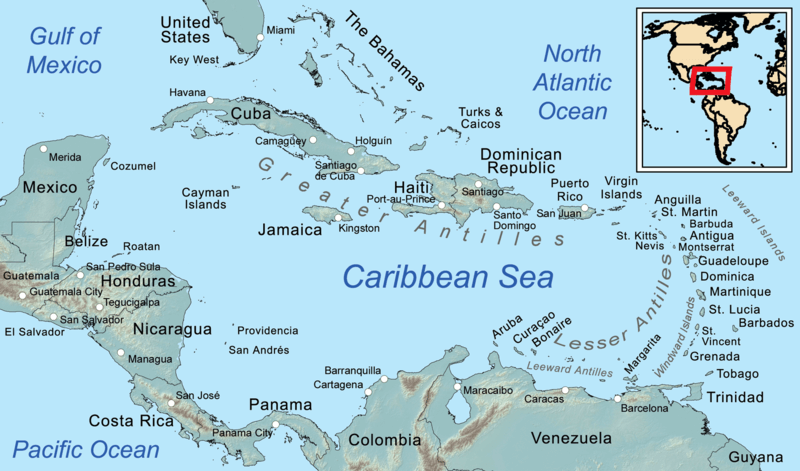
Map depicting the regions of the Caribbean.
Notable Islands
Anguilla
Anguilla, a British Overseas Territory covering 91 sq km (35 sq mi), has one of the most unusual histories in the Caribbean: in 1967, when Britain attempted to incorporate it into a federated state with St. Kitts and Nevis, Anguillans staged a peaceful revolt and demanded separation. Their insistence on remaining a British territory, rather than pursuing independence, was sufficiently anomalous that it became known as 'the revolution that went the wrong way.' Today, Anguilla's economy is almost entirely tourism-based, and its reefs and beaches are protected by several marine parks.
Antigua and Barbuda
Antigua covers 281 sq km (108 sq mi) and is said to have 365 beaches — one for each day of the year, though the count is optimistic. Its most historically significant site is Nelson's Dockyard in English Harbour, the only continuously maintained Georgian-era dockyard in the world and the base from which Admiral Horatio Nelson commanded Caribbean naval operations in the 1780s. Now a UNESCO World Heritage Site, English Harbour is also one of the premier yachting centres in the Caribbean. Barbuda, 160 sq km (62 sq mi) of flat coral limestone to the north, hosts the Codrington Lagoon, a 16 km (10 mi) long lagoon that shelters the largest colony of magnificent frigatebirds (Fregata magnificens) in the Lesser Antilles, with an estimated 5,000 nesting pairs. Hurricane Irma in 2017 caused near-total destruction of Barbuda's buildings and forced the evacuation of virtually its entire population.
Saint Kitts and Nevis
Saint Kitts (Saint Christopher) covers 168 sq km (65 sq mi) and was the 'mother colony' of the British Caribbean — the springboard from which British colonists spread throughout the Lesser Antilles in the 17th century. Its volcanic interior rises to 1,156 m (3,793 ft) at Mount Liamuiga, a dormant volcano whose name in the Kalinago language means 'fertile land.' The island's Southeast Peninsula, connected to the main island by a narrow sandy isthmus, is protected within a national park and supports populations of the St. Kitts vervet monkey (Chlorocebus sabaeus), introduced from West Africa during the colonial period and now present in such numbers that they are considered a pest by farmers.
Nevis, covering 93 sq km (36 sq mi) and separated from St. Kitts by a 3.2 km (2 mi) channel called The Narrows, is dominated by Nevis Peak, a near-perfect volcanic cone rising to 985 m (3,232 ft) and almost perpetually shrouded in cloud. The island is the birthplace of Alexander Hamilton, the American Founding Father and first Secretary of the Treasury; the house where he was born in Charlestown is now a museum. Nevis is also renowned for its 18th-century plantation great houses, several of which have been converted into small luxury inns.
Montserrat
Montserrat, covering 102 sq km (39 sq mi) and known as the 'Emerald Isle of the Caribbean' for the Irish heritage of many early settlers, is defined above all by the Soufrière Hills volcano. Dormant since at least the 18th century, the volcano erupted catastrophically in 1995, destroying the southern two-thirds of the island, including the capital, Plymouth, and forcing the evacuation of approximately two-thirds of Montserrat's population. Plymouth, now buried under metres of volcanic debris and cooling pyroclasts, is sometimes called the 'Caribbean Pompeii' and can be observed from designated viewing areas. The Montserrat oriole (Icterus oberi), endemic to the island and its national bird, was severely threatened by habitat loss from the eruption but has survived in the northern Centre Hills, where ongoing conservation work monitors and protects the remaining population.
Guadeloupe
Guadeloupe is the most populous of the Leeward Islands, with a population of approximately 400,000, and, as a French overseas region, its residents are full citizens of the European Union. The island group's cultural character is a vibrant synthesis of French metropolitan culture, African traditions, and Caribbean Creole identity. The music form gwo ka — a percussion-based tradition rooted in the experience of enslaved Africans — was inscribed on UNESCO's Representative List of the Intangible Cultural Heritage of Humanity in 2014. Guadeloupe National Park, covering 21,850 ha (54,000 acres) of the Basse-Terre interior, protects one of the most intact rainforest systems in the Lesser Antilles, sheltering the endemic Guadeloupe woodpecker (Melanerpes herminieri) and Guadeloupe raccoon (Procyon minor), among many other species.
Environmental Significance
The Leeward Islands contain some of the most significant protected marine areas in the Caribbean. The Saba National Marine Park, established in 1987, encompasses all of Saba's coastal waters to a depth of 200 m (656 ft) and has become a global model for small-island marine management. Its reefs, which drop precipitously from the island's volcanic flanks into deep blue water, are renowned for large pelagic species, including nurse sharks (Ginglymostoma cirratum), Caribbean reef sharks (Carcharhinus perezi), and whale sharks (Rhincodon typus) during seasonal migrations.
The terrestrial ecosystems of the volcanic Leeward Islands support high levels of endemism. Basse-Terre's cloud forests harbor species found nowhere else, including the Guadeloupe woodpecker. The coral reefs of Antigua's south coast and the reef systems of the British Virgin Islands support hundreds of fish species and provide nursery habitat for commercially vital snapper and grouper populations.
Cultural Heritage and Identity
The cultural landscape of the Leeward Islands is as varied as its political map. English, French, Dutch, and their respective creoles are spoken across the chain, and the traditions of cricket, carnival, and Creole cuisine are refracted through each island's particular colonial history. The West Indies cricket team, which draws players from across the English-speaking Caribbean, has long embodied a pan-Caribbean identity that transcends political boundaries.
Antigua's annual Carnival — held in late July and early August to coincide with the anniversary of emancipation — is one of the Caribbean's great festivals, drawing the diaspora home and showcasing the island's vibrant calypso and soca traditions. On the French islands, Carnival is celebrated in the pre-Lenten period with a cultural intensity that reflects the islands' deep African heritage, culminating in the burning of 'Vaval,' the king of Carnival. Sint Maarten/Saint Martin's split governance creates the extraordinary spectacle of two carnivals on one island: the French Carnival before Easter and the Dutch Carnival in April.
Conclusion
The Leeward Islands defy easy summary. In a geography of only a few thousand square kilometres, they encompass active volcanoes and coral atolls, French overseas departments and British territories, some of the Caribbean's most exclusive resorts, and some of its most authentic cultural communities. Their history is one of extraordinary richness and extraordinary suffering — from the first Caribbean colony at St. Kitts to the buried capital of Montserrat — and their future depends on small island communities' ability to navigate the twin challenges of climate change and economic vulnerability while preserving what makes each island irreplaceable.