The Lesser Antilles: Arc of Islands Between Two Oceans
Nestled in the heart of the Caribbean Sea, the Lesser Antilles form an island chain that stretches between the Greater Antilles and South America. Comprising a mix of volcanic and non-volcanic islands, the archipelago boasts stunning landscapes, rich cultural heritage, and unique ecosystems.


The Lesser Antilles: Geology, Biodiversity, and Cultural Crossroads of the Eastern Caribbean
The Lesser Antilles form a curving chain of islands that stretches approximately 800 km (500 mi) from the Virgin Islands in the north to Trinidad and Tobago near the coast of Venezuela in the south. Separating the Caribbean Sea from the Atlantic Ocean, these islands mark the eastern boundary of the Caribbean basin and encompass a remarkable range of geological ages, ecological types, and cultural traditions within a relatively compact arc.
The archipelago is conventionally divided into three groups: the Leeward Islands in the north, the Windward Islands in the south, and the Leeward Antilles (or ABC islands) to the southwest near the Venezuelan coast. Together they represent some of the Caribbean's most distinctive landscapes — from the still-active volcanic summits of Dominica and Montserrat to the near-flat coral limestone platforms of Anguilla and Barbuda, and from the arid cacti-studded hills of Aruba to the mist-draped rainforests of St. Vincent.
Geological Setting
The Lesser Antilles owe their existence to the subduction of the North American Plate beneath the Caribbean Plate, a process that has generated a chain of volcanic islands along the inner arc of the archipelago. These younger volcanic islands — including Dominica, St. Vincent, Grenada, Martinique, and St. Kitts — are characterised by steep terrain, fertile volcanic soils, dense rainforest, and ongoing geothermal activity. Dominica, in particular, is so young and geologically active that it has no less than nine active volcanic centres, boiling lakes, and fumarole fields, earning it the sobriquet the 'Nature Island' of the Caribbean.
The outer arc of the Lesser Antilles, by contrast, consists of older, eroded volcanic islands and coral limestone platforms. Islands such as Anguilla, Barbuda, and the eastern portions of Guadeloupe (Grande-Terre) are low-lying and composed largely of carbonate rock, giving them flat or gently rolling topography, brilliant white sand beaches, and extensive barrier reefs. The Leeward Antilles — Aruba, Bonaire, and Curaçao — are continental shelf fragments with no volcanic origin, quite unlike the rest of the chain, a distinction that gives them their characteristic arid climate and striking contrast of desert scrub and turquoise sea.
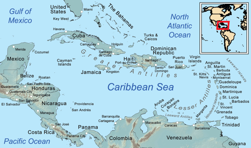
Map depicting the island groups of the Caribbean region: the Lesser Antilles are shown in the southeast.
The Leeward Islands
The Leeward Islands occupy the northern portion of the Lesser Antilles chain, running southeast from the Virgin Islands to Guadeloupe. The name derives from their position relative to the prevailing northeasterly trade winds: they lie in the partial shelter, or lee, of the wind relative to Caribbean sea lanes — though in practice the distinction from the Windward Islands to their south is more historical and conventional than strictly meteorological.
This group encompasses an extraordinary degree of political and cultural diversity within a small geographic space. The Virgin Islands are divided between the United States (St. Thomas, St. John, St. Croix, and Water Island) and the United Kingdom (Tortola, Virgin Gorda, Anegada, Jost Van Dyke, and approximately 56 smaller cays). To their south, Anguilla remains a British Overseas Territory, while nearby Sint Maarten/Saint-Martin is shared between the Netherlands and France — the only land border between these two nations anywhere in the world, famously unguarded and maintained by a 1648 treaty. Saint Barthélemy, with its French sophistication and exclusive resorts, lies close to the Dutch/French island of Sint Eustatius (Statia), a tiny island with an outsized 18th-century history as the trading hub of the Atlantic world.
Further south, Saint Kitts and Nevis form a federated independent nation, while Antigua and Barbuda — also independent — are renowned for Antigua's 365 beaches and Barbuda's Codrington Lagoon, home to the largest frigatebird (Fregata magnificens) colony in the Caribbean, estimated at 5,000 or more nesting pairs. Montserrat, a British Overseas Territory, is defined by the still-active Soufrière Hills volcano, whose 1995 eruption buried the former capital, Plymouth, under metres of pyroclastic debris and ash. Guadeloupe, administratively an overseas region of France, is itself an archipelago, its two main islands — Basse-Terre (volcanic and mountainous) and Grande-Terre (low limestone plateau) — separated by a mangrove-lined channel called the Rivière Salée. La Soufrière on Basse-Terre, at 1,467 m (4,813 ft), is the highest point in the Lesser Antilles.
The Windward Islands
South of Dominica, the Windward Islands take their name from their more exposed position to the Atlantic trade winds, which historically made these coasts harder to approach and defend. This group extends from Dominica through Martinique, Saint Lucia, Saint Vincent and the Grenadines, and Grenada, with Barbados lying somewhat to the east as an outlier on the Atlantic side of the chain.
The Windward Islands are characterised by dramatic volcanic landscapes, lush forests, and a cultural heritage that reflects intense French and British colonial rivalry. Martinique and Guadeloupe remain French overseas regions, their populations French citizens, their currency the euro, and their administrative ties to Paris closer than to any neighbouring Caribbean state. In 1902, the eruption of Mount Pelée on Martinique killed an estimated 30,000 people — virtually the entire population of the colonial capital Saint-Pierre — in one of the deadliest volcanic events in recorded history.
Saint Lucia changed hands between Britain and France no fewer than fourteen times before finally becoming British in 1814, and this colonial tug-of-war left the island with a French Creole language and culture alongside English law and government. Its twin volcanic plugs, Gros Piton (770 m / 2,526 ft) and Petit Piton (743 m / 2,438 ft), are among the most dramatic landforms in the Caribbean and form part of a UNESCO World Heritage Site. Grenada, the 'Spice Isle,' produces roughly 20% of the world's nutmeg (Myristica fragrans) and is also significant for its mace, cloves, and cinnamon. Saint Vincent and the Grenadines extends south through a 90 km (56 mi) chain of 32 islands and cays, the most celebrated of which — Mustique and the Tobago Cays — are world-renowned for their beaches and sailing waters.
The Leeward Antilles
Aruba, Bonaire, and Curaçao — the ABC islands, often called the Leeward Antilles or Dutch Caribbean — lie less than 100 km (62 mi) from the Venezuelan coast and outside the hurricane belt, a geographical position that distinguishes them sharply from the rest of the Lesser Antilles. All three are autonomous territories within the Kingdom of the Netherlands, though their political structures differ: Aruba and Curaçao have 'constituent country' status with significant self-governance, while Bonaire is a special municipality of the Netherlands with direct Dutch oversight.
The ABC islands' climate is semi-arid, shaped by the rain shadow of the Venezuelan Andes, and their vegetation consists largely of xerophytic scrub dominated by the endemic kadushi cactus (Cereus repandus) and the divi-divi tree (Caesalpinia coriaria), which grows at a characteristic windward-leaning angle due to the persistent trade winds. Bonaire's coral reefs are among the most pristine in the Caribbean, protected by the Bonaire National Marine Park, and the island's commitment to reef conservation has made it one of the world's premier scuba diving destinations. Aruba's south coast features the Pink Beach, named for the crushed coral that tints its sands, while Curaçao's capital, Willemstad, is a UNESCO World Heritage Site celebrated for its brightly painted Dutch colonial townhouses and its iconic Handelskade waterfront.
East of the ABC islands, stretching along the Venezuelan coast toward Trinidad, lies the Venezuelan portion of the Leeward Antilles: a scattered constellation of islands, archipelagos, and cays politically divided between the state of Nueva Esparta and the Federal Dependencies of Venezuela. These territories, though far less visited internationally than their Dutch counterparts, encompass some of the most ecologically intact marine environments in the Caribbean, as well as one of the region's most historically significant island groups.
Ecology and Biodiversity
The Lesser Antilles are a recognised global biodiversity hotspot. Despite their small collective land area, the islands support hundreds of endemic species, concentrated above all in the inner volcanic arc, where dense rainforests have provided long-term refugia for evolutionary diversification. The endemic Imperial amazon (Amazona imperialis) and Red-necked amazon (Amazona arausiaca), both found only on Dominica, represent two of the most endangered parrots in the world. The Saint Vincent amazon (Amazona guildingii) is similarly restricted to its namesake island and is Vulnerable according to the IUCN Red List.
Marine biodiversity is exceptional throughout the chain. Coral reefs supporting more than 500 species of fish, hawksbill sea turtles (Eretmochelys imbricata), green turtles (Chelonia mydas), and leatherback turtles (Dermochelys coriacea) nest on beaches from Barbuda to Trinidad. The Soufrière-Scotts Head Marine Reserve in Dominica protects an underwater volcanic landscape of extraordinary richness, including black smoker vents, wall dives, and sponge gardens that attract experienced divers from around the world.
Cultural Heritage
The cultural landscape of the Lesser Antilles is a product of layered histories: Indigenous Arawak and Kalinago (Carib) civilisations, Spanish, French, British, Dutch, and Danish colonial rule, and the African diaspora that accompanied centuries of plantation slavery. The Kalinago people, who gave the Caribbean its name and fiercely resisted European colonisation, maintain a Territory on Dominica — the only remaining pre-Columbian Indigenous community in the Lesser Antilles — where approximately 3,000 people preserve traditional weaving, boat-building, and language.
Music is perhaps the most globally resonant product of Lesser Antillean culture. Calypso and soca originated in Trinidad and Tobago and spread through the eastern Caribbean; Martinique and Guadeloupe gave the world zouk; Saint Lucia has produced acclaimed jazz artists and writers, including Nobel laureate Derek Walcott. Carnival, celebrated with particular intensity in Trinidad and Martinique, represents the fullest expression of Afro-Caribbean creative tradition — a fusion of African masquerade, French Mardi Gras, and Caribbean rhythmic invention that draws hundreds of thousands of participants annually.
The cuisine of the Lesser Antilles reflects similar complexity. Flying fish (Hirundichthys affinis) and cou-cou (cornmeal with okra) are the national dish of Barbados; roti, brought by South Asian indentured labourers who arrived after emancipation, is staple fare across Trinidad and Tobago and increasingly throughout the chain; accras de morue (salt cod fritters) are ubiquitous in the French islands; and 'oil down,' a one-pot stew of breadfruit, callaloo, and salted meat cooked in coconut milk, is the national dish of Grenada.
Conservation Challenges
The Lesser Antilles face acute environmental pressures despite — and in some cases because of — their small size and high tourist appeal. Rising sea temperatures driven by climate change are causing increasingly frequent mass coral-bleaching events, with some reef systems having lost 50% or more of their live coral cover since the 1980s. Hurricane intensity has grown alongside sea surface temperatures: Hurricanes Irma and Maria in 2017 caused catastrophic damage across the northern Leeward Islands, leaving Barbuda virtually uninhabited for several months after the near-total destruction of its infrastructure.
Invasive species pose a severe threat to endemic biodiversity. The small Indian mongoose (Urva auropunctata), introduced to control snakes in sugarcane fields, has devastated ground-nesting birds and reptiles across many islands. The lionfish (Pterois volitans and P. miles), native to the Indo-Pacific and accidentally introduced to the Caribbean, has spread rapidly through the region's reefs since the 1990s, with no natural predators to control its numbers. Conservation organisations, local governments, and the tourism industry are increasingly working together to manage these threats, invest in marine protected areas, and restore degraded habitats.
Conclusion
The Lesser Antilles are a world unto themselves — geologically young and old, ecologically irreplaceable, and culturally inexhaustible. Their islands represent the meeting point of ocean currents and trade winds, of African, European, and Indigenous traditions, of volcanic fire and coral limestone. To understand the Caribbean is, in large measure, to understand the Lesser Antilles: their history, their ecosystems, and the resilient communities that have shaped — and continue to shape — this extraordinary arc of islands between two seas.