Nueva Esparta: Venezuela's Island State and the Legacy of the Pearl Coast
Nueva Esparta is the smallest state in Venezuela, consisting of Margarita Island, Coche Island, and Cubagua Island. It is known as the "Isle of Pearls" due to its historical association with pearl fishing. Beyond its bustling towns and historical sites, it is renowned for stunning beaches and rich biodiversity.
 called Playa Puerto Cruz. Hotel at the right is the Dunes Beach Resort Hotel. In the background is the Hesperia Isla Bonita Hotel. The picture was taken from the lighthouse. - public domain")


]")

]")

Nueva Esparta: Three Islands, a Thousand Years of History, and the Caribbean at its Most Vivid
Off the northeastern coast of Venezuela, where the Caribbean Sea meets the warm currents sweeping up from the Orinoco Delta, three islands rise from shallow, pearl-rich waters to form South America's only insular state. Nueva Esparta — comprising Margarita, Coche, and Cubagua — is the smallest of Venezuela's 23 states by area, yet it carries one of the most layered and consequential histories in the entire Caribbean. These are islands shaped first by the skilled Indigenous peoples who lived from their waters for millennia, then dramatically transformed by the Spanish hunger for pearls, and ultimately forged into a distinct identity through revolution, resilience, and an enduring connection to the sea. The name itself tells part of the story: Nueva Esparta, or "New Sparta," was conferred by the young Venezuelan republic in honour of the extraordinary courage shown by Margarita's people during the War of Independence — a tribute that would have seemed apt to anyone who understood just how much these islands had already survived.
Geography and Setting
Nueva Esparta lies approximately 30 kilometres (19 miles) off the coast of the Sucre state on the Venezuelan mainland, occupying a total area of roughly 1,150 square kilometres (444 square miles). The three islands are clustered together in the southeastern Caribbean, with Margarita by far the largest, Coche a modest presence to its south, and the tiny, bone-dry outcrop of Cubagua nestled between Coche and the mainland's Araya Peninsula.
Margarita Island dominates the state in every sense. Stretching approximately 78 kilometres (48 miles) from east to west and up to 20 kilometres (12 miles) from north to south, it covers around 1,020 square kilometres (394 square miles) and has a deeply indented coastline of some 318 kilometres (198 miles). The island's most striking geographic feature is its distinctive double-lobed shape: two mountainous masses — the Paraguachoa Peninsula to the east and the Macanao Peninsula to the west — are joined by a narrow, low-lying isthmus barely wide enough in places to hold a road. This isthmus creates two entirely different Margaritas on either side of it. The eastern half is the more developed, greener, and densely populated, home to the state capital La Asunción, the commercial city of Porlamar, and the popular resort town of Pampatar. The western Macanao Peninsula is wilder, more arid, and far less visited, its central mountain range rising to 760 metres (2,493 feet) at the Cerros del Macanao — a surprisingly rugged landscape for a Caribbean tourist island.
Coche, lying about 10 kilometres (6 miles) south of Margarita, is a flat, wind-scoured island of some 55 square kilometres (21 square miles), home to a few small fishing villages and a coastline that has attracted a devoted following among kitesurfers. Cubagua, the smallest at just 24 square kilometres (9 square miles), sits a few kilometres to the south. Flat, treeless, and without any natural freshwater, it appears almost uninhabitable — and yet it was here, on this unlikely sliver of Caribbean rock, that the story of Spanish colonial Venezuela effectively began.
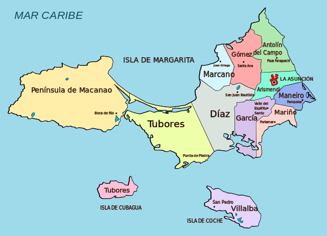
Illustration depicting the territorial political division of Nueva Esparta.
The First Peoples: Guaiquerí and the Sea
Long before any European vessel appeared on the horizon, the islands of what is now Nueva Esparta were known to successive waves of Indigenous settlement. Archaeological evidence indicates human presence on and around the islands dating back at least 1,500 to 2,000 years, with Arawak- and Carib-speaking peoples passing through as part of the broader path of island-hopping migration that characterised the pre-Columbian settlement of the Caribbean. By the time of European contact, the dominant people of these islands were the Guaiquerí, a group whose linguistic and cultural affiliations have been debated by scholars — some linking them to the Arawak tradition, others to Carib-speaking groups of the Cumanagotos. What is not in question is that the Guaiquerí were accomplished mariners and fishermen, with an intimate knowledge of the surrounding waters and a social organisation well adapted to island life.
The Guaiquerí knew Margarita as Paraguachoa, meaning "fish in abundance" — a name that captured both the ecological richness of the surrounding sea and the centrality of fishing to their way of life. Coche was called Cochen, meaning "deer" in the Guaiquerí language, after the animals that once roamed the island. Cubagua, they knew as Cua Hua. They were regarded with unusual respect by the Spanish colonial authorities, who — remarkably for the era — granted them freedom from tribute and servitude by royal decree, referring to them in official documents as "my Guaiquerí gentlemen." Some historians believe this status was granted partly because the Guaiquerí collaborated with Spanish pearl operations, acting as experienced divers and navigators; others suggest it reflected genuine recognition of their peaceful nature and skilled seamanship. Descendants of the Guaiquerí still inhabit Margarita today, their ancestral knowledge of fishing techniques and the sea surviving in cultural memory if not always in a distinct community identity.
Pearls, Conquest, and the Rise of Nueva Cádiz
Christopher Columbus reached these waters on August 15, 1498, during his third voyage to the Americas — the same expedition on which he first sighted the South American mainland. He encountered three islands: two small, flat, and arid (Cubagua and Coche), and one larger and verdant (Paraguachoa, which he would rename Margarita, from the Latin for "pearl"). It did not take long for word to spread. According to the Dominican friar Bartolomé de las Casas, by 1500 — just two years after Columbus's sighting — approximately fifty Spanish adventurers had already installed themselves on Cubagua, drawn by the knowledge of pearl-rich oyster beds that the Indigenous people had pointed out to the newcomers.
The pearl oyster in question was Pinctada imbricata, a species native to the Caribbean whose beds around Cubagua were among the richest ever found anywhere in the world. The Spanish quickly recognised that the island itself mattered less than what lay beneath the surrounding sea. What followed was one of the most feverish extractive booms in early colonial history. The Guaiquerí from Margarita, along with enslaved Indigenous people brought from the mainland, were put to work diving for oysters — sometimes for up to sixteen hours a day — in conditions that caused terrible suffering. Las Casas, who documented the abuses with unflinching detail, described the pearl trade as among the most brutal enterprises of the entire conquest.
Despite these grim foundations, the settlement on Cubagua grew rapidly. By 1510, it had a governing council; by 1521, Spain granted a charter for a formal town; and on September 13, 1528, it was elevated to the rank of city and renamed Nueva Cádiz — the first settlement in Venezuela to hold that title, and one of the earliest formally established cities anywhere in South America. At its peak, Nueva Cádiz was a busy, prosperous place of stone houses, churches, a customs house, and warehouses packed with pearls destined for the Spanish crown and the jewellers of Europe. The city was so well-known that a type of glass trade bead used in commerce with Indigenous peoples across the Americas came to be named after it.
The boom proved unsustainable. By the early 1530s, the oyster beds were showing signs of exhaustion from over-harvesting. The chronic problem of supplying food and fresh water to an island with neither arable land nor rivers compounded the difficulty. Then, in 1541, a catastrophic earthquake and associated tsunami struck the island, devastating Nova Cádiz and killing a significant portion of its population. A subsequent attack by French Huguenot raiders, who had mistakenly assumed the city was still a functioning pearl centre, finished what the disaster had begun. By the mid-sixteenth century, Nueva Cádiz was abandoned, its stone buildings left to the wind and salt. Today, the ruins are a designated National Monument of Venezuela, and the waters around Cubagua — where pearl oysters have never fully recovered — are popular with scuba divers who move through the ghostly footprint of what was once one of the most talked-about cities in the Americas.
Pearl harvesting shifted to Coche Island, where oyster beds were discovered and exploited from 1574, and, in a more limited way, to Margarita itself, but the era of the bonanza was over. The pearl oyster (Pinctada imbricata) populations in the entire region were so severely depleted that commercial harvesting eventually became impossible. The complete exhaustion of the Cubagua beds was formally acknowledged by 1857.
Independence, Fortifications, and the Name "New Sparta"
The centuries between the pearl bust and Venezuelan independence were not quiet ones for these islands. Margarita's position on the main shipping route between the Spanish Main and Europe made it a perpetual target for pirates and privateers — English, Dutch, and French raiders all attacked the island's coasts at various times during the sixteenth and seventeenth centuries. The Spanish response was to fortify it heavily. Several of those fortifications survive today as among the most compelling historical monuments in the Venezuelan Caribbean. The Castillo de Santa Rosa in La Asunción, built in the seventeenth century on a hilltop overlooking the capital, was used as a prison during the colonial era and later during the independence struggle. The Fortaleza de La Galera at Juan Griego guards a sweeping bay on the island's north coast, its cannons now aimed at nothing more threatening than a spectacular sunset.
When the Venezuelan independence movement gathered momentum in the early nineteenth century, Margarita emerged as one of its most ardent centres. The island declared independence from Spain in 1814 — the first territory in Venezuela to do so permanently — and its fighters played a decisive role in the broader conflict. Simón Bolívar, the liberator of much of South America, used Margarita as a strategic base during the reconquest of the mainland in 1816, landing on the island to regroup and gather support before launching campaigns that would ultimately drive Spain from the continent. In recognition of the island's extraordinary contribution to the independence cause — a resistance that, in the face of vastly superior Spanish military power, was considered to rival the legendary courage of ancient Sparta — the new republic gave the island state the name it carries to this day. In 1864, when Venezuela reorganised its territories into states, the name Nueva Esparta was formally enshrined.
Landscapes and Natural Environments
The climate of Nueva Esparta is tropical and predominantly arid, shaped by the dry trade winds that dominate this part of the Caribbean coast. Average temperatures on Margarita hover around 27–32°C (81–90°F) throughout the year, with daytime highs occasionally exceeding 34°C (93°F) and cooler nights typically between 22°C (72°F) and 23°C (73°F). Annual rainfall is scarce: on Coche and Cubagua, it averages around 250 millimetres (10 inches) per year, creating near-desert conditions. On Margarita, rainfall is somewhat more generous, particularly in the mountainous interior, where the wet season runs roughly from July to October.
That aridity defines the character of the landscape. The lower slopes of Margarita and virtually all of Coche and Cubagua are clothed in xerophytic vegetation — a dry-adapted assembly of columnar cacti, prickly pear (Opuntia spp.), thorny shrubs, and guamache trees (Pereskia guamacho), the last a curious member of the cactus family that retains true leaves and produces bright pink flowers after rain. The contrast between these near-desert lowlands and the moister, forested hills of eastern Margarita — where the Cerro El Copey National Park protects cloud forest and freshwater springs at elevations approaching 900 metres (2,953 feet) — is one of the island's most striking ecological features. Within a short drive, a visitor can pass from cactus scrub to lush, fern-draped forest dripping with humidity, a transition that underlines just how topographically and climatically varied Margarita is for its size.
La Restinga: A Wetland of International Importance
The ecological crown of Nueva Esparta is Laguna de La Restinga National Park, established in 1974 and subsequently designated a Ramsar Wetland of International Importance and an Important Bird Area by BirdLife International. The park protects a shallow saline lagoon of approximately 2,500 hectares (6,178 acres), fringed and threaded by mangrove forest and separated from the open Caribbean Sea by a remarkable natural sandbar — La Restinga itself — that stretches for some 24 kilometres (15 miles) across the isthmus connecting eastern Margarita to the Macanao Peninsula. This bar of compacted sea shells and sand supports its own distinctive vegetation of buttonwood mangroves, dry grasses, and beach scrub, while the Caribbean-facing side offers 15 kilometres (9 miles) of beach where vendors sell freshly harvested oysters to visitors.
Four main channels wind through the mangrove interior of the lagoon, and boat tours through these passages — aboard the traditional wooden peñeros guided by local boatmen whose families have worked these waters for generations — are one of Margarita's most memorable experiences. The channels bear poetic names: El Tesoro (The Treasure), Mi Dulce Amor (My Sweet Love), and El Túnel de los Enamorados (Lovers' Tunnel), where mangrove branches knit overhead, creating a green, cathedral-like passage. The lagoon's shallow waters, at most 2.4 metres (8 feet) deep, support red snapper, grunt, sardines, black mullet, and swordfish, as well as oysters that grow directly on submerged mangrove roots.
Three species of mangrove dominate the forest: red mangrove (Rhizophora mangle), black mangrove (Avicennia germinans), and white mangrove (Laguncularia racemosa), each occupying a slightly different ecological niche within the wetland. Their interlocking root systems trap sediment, filter nutrients, and provide irreplaceable nursery habitat for juvenile fish and shellfish. At least 132 bird species have been recorded in the park, including 21 migratory species that use the wetlands as resting and feeding stopover sites. Among the most spectacular residents are the American flamingo (Phoenicopterus ruber), scarlet ibis (Eudocimus ruber), magnificent frigatebird (Fregata magnificens), and a range of herons, egrets, and cormorants. The park also protects three species endemic to Margarita Island: the Margarita white-tailed deer (Odocoileus carriacou margaritae), the Margarita cottontail rabbit (Sylvilagus floridanus margaritae), and the Margarita thread snake (Leptotyphlops albifrons margaritae).
Culture, Identity, and the Virgen del Valle
The cultural life of Nueva Esparta is a vivid weave of Indigenous memory, Spanish colonial heritage, Afro-Caribbean tradition, and the particular character that island communities develop when geography sets them apart. The margariteño identity — proud, independent, and deeply tied to the sea — is one of the most distinctive regional identities in Venezuela, and it manifests in everything from the local dialect to music and festivals.
The most important religious event in the state's calendar is the annual festival of the Virgen del Valle, patron saint of Margarita Island and, by extension, of Venezuelan fishermen and the country's navy. Held in early September, the celebration draws tens of thousands of pilgrims to the Basílica Menor de Nuestra Señora del Valle, a colonial-era church in the town of El Valle del Espíritu Santo on the eastern side of Margarita. The image of the Virgin, elaborately dressed in jewels and robes, is processed through the town in scenes of intense popular devotion. For the fishing communities of the island, the festival carries particular weight: sailors depart and return under her protection, and model boats are among the offerings left at her shrine.
Music is another pillar of margariteño identity. The galerón margariteño, a vocal tradition in which two or more performers engage in improvised poetic competition — trading verses on themes ranging from nature and love to philosophy and current events — is considered one of the most refined forms of Venezuelan folk music. Its roots lie in the Spanish sung-poetry tradition brought by colonial settlers, reshaped over centuries by the island's particular culture. The Diablos Danzantes (Dancing Devils), a tradition recognised by UNESCO as Intangible Cultural Heritage, takes on a unique form in Nueva Esparta, where performers wear masks adorned with pearls — a direct nod to the islands' history — while enacting symbolic battles between good and evil.
The local cuisine draws heavily from the sea. Pescado frito margariteño — fried fish with tostones (fried green plantain) and rice — is the staple dish of the coast, available at the informal beachside restaurants that line the island's shores. Empanadas de cazón, filled with baby shark meat, are a beloved street food. Oysters from La Restinga are served fresh from the shell along the lagoon's edge. And chicha de arroz, a sweet rice drink, and local rum-based preparations reflect both the Spanish colonial inheritance and the resourcefulness of an island culture that has always made the most of what the land and sea provide.
Tourism, Economy, and Contemporary Challenges
For much of the late twentieth century, Margarita Island was one of the premier holiday destinations in the Caribbean — a free port since 1974, with duty-free shopping, an international airport, and a range of beaches, resorts, and historical sites that attracted large numbers of Venezuelan and international visitors. The island's beaches remain genuinely compelling. Playa El Agua on the northeastern coast is a long, surf-facing Atlantic beach backed by beach bars and restaurants, widely considered one of Venezuela's finest. Playa Parguito, nearby, draws surfers to its more exposed waves. Playa Puerto Cruz and Playa Pampatar on the calmer Caribbean side offer sheltered swimming, while the kitesurfing and windsurfing conditions at El Yaque, near the airport, are among the best in the Caribbean and attract dedicated watersports visitors from across the world.
Historical tourism offers its own rewards. The colonial city of La Asunción, with its cathedral and the hilltop Castillo de Santa Rosa, retains a quiet, well-preserved dignity. The Museum of Nueva Cádiz, in the same city, holds artefacts recovered from excavations on Cubagua — fragments of European ceramics, pearl-fishing equipment, and objects from the Indigenous communities — that bring the extraordinary story of the first Spanish city in Venezuela to life. On Cubagua itself, the ruins of Nueva Cádiz are accessible only by private boat, and the absence of any permanent settlement or tourist infrastructure means the experience of walking through the remnants of the first city retains an atmosphere of genuine discovery.
Venezuela's prolonged economic and political crisis from the mid-2010s onwards dealt a severe blow to the island's tourism economy. Hotel occupancy rates collapsed, infrastructure deteriorated, and many international airlines suspended services. The free-port shopping culture, a major draw, lost much of its appeal as the national economy contracted. Despite this, Nueva Esparta's natural assets remain undiminished — its beaches, its extraordinary wetlands, the vivid life of its fishing communities, and the weight of its history are all still there, waiting. The islands of Margarita, Coche, and Cubagua together tell a story that spans the Indigenous Caribbean, the earliest decades of European colonisation, the birth of Venezuelan nationhood, and the ongoing resilience of a people long accustomed to living with — and from — the sea.